While animal keeping is one of my great loves, so is backpacking. The High Sierra in Sequoia and Kings Canyon national parks has a very special place in my heart. They're not only in my backyard (I live east of Fresno), but backpacking in these mountains has been in my family for a long time. Here are some of my favorite pictures I've taken, hopefully you'll enjoy them. Descriptions will be under each picture.

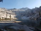
A view of Aster lake on the Lakes Trail in Sequoia NP, beyond the lake is Tokopah valley. This trail has four incredible alpine lakes along it.

This was taken from the top of Sawtooth Pass (about 12,000ft) in the Mineral King are of Sequoia NP. In the picture you can see Columbine Lake, Lost Canyon beyond that, and Big Arroyo Canyon running perpendicular way back there. Sawtooth Peak lays just out of frame to the right extending several hundred more feet upward in dramatic fashion.
We were getting chased off the pass by quick approaching thunderstorms so unfortunately I only got a few pictures from this location.

Looking down Big Arroyo from Kaweah Gap. If I'm not mistaken, that's Sawtooth peak sticking it's nose out in the distance center frame.

This is a picture from the High Sierra Trail between Kaweah Gap and Hamilton Lake - a grueling steep stretch of trail in an area know as "Valhalla" - a valley full of stunning granite formations. This picture shows the scale of the environment, I'm on the left third in case you missed it. I'm an ant in this place.

Looking Down from Precipice Lake (truly, one of the most beautiful lakes in the entire Sierra Nevada. I encourage you to google it. It was storming when we reached it so the pictures I took didn't do any justice.) This view is looking down into the Kaweah Valley. In the center of the picture you can see Valhalla. It looks small here but it incredibly large and dramatic when you get down below it. On the far right of the picture is Big Bird Peak, and just off frame is Elizabeth Pass way in the distance.

Another view of Valhalla, this time from the north, on the west side of Elizabeth Pass. In this picture you can see the back side of the structure in the pervious picture in the center. Opposite that lies the angel wings.

From the top of Elizabeth pass at 11,375ft, which straddles the border between Sequoia and Kings Canyon (or rather the Kings/Kaweah Divide). This is the headwall of Deadman Canyon, one of the most special places to me as it was a favorite of my grandfathers. Unfortunately he passed before I took up an interest in backpacking. Putting my body and mind through hell and back to get to these places is my way of honoring him and our relationship. Even better is that I've been able to convince my wife she actually enjoys hiking 15 miles a day at high elevation, so she experiences these places with me")


The top is my grandfather in the 60's, obviously I'm on the bottom. I'm facing a different way because the lighting was more forgiving, but both are in the same spot, Elizabeth Pass.

Looking down from Elizabeth Pass into Deadman Canyon.

From the floor of Deadman Canyon, this is on the other side of that curve seen in the previous picture. Beautiful pockets of meadows and lodgepole pine are spattered along the canyon. A river runs down from the headwall springs and snakes through the length of the canyon.

To the left of of Triple Peaks is another peak called the Horn Col. To the right is the steep granite slabs that lead up to massive Big Bird lake and Big Bird peak. We decided to skip hiking to Big Bird lake, as much as I hoped we could see it. We were about 30 miles into this hike when this photo was taken and didn't have the energy. It'll be there in the future.

I added this last picture because it's just a great example of the moonscape terrain the High Sierra is known for. In the distance you can see Moose Lake, also massive, and much of the Tablelands. Alta Peak also sits in the distance. Below it sits the Lakes trail, where the first picture was taken.
A view of Aster lake on the Lakes Trail in Sequoia NP, beyond the lake is Tokopah valley. This trail has four incredible alpine lakes along it.
This was taken from the top of Sawtooth Pass (about 12,000ft) in the Mineral King are of Sequoia NP. In the picture you can see Columbine Lake, Lost Canyon beyond that, and Big Arroyo Canyon running perpendicular way back there. Sawtooth Peak lays just out of frame to the right extending several hundred more feet upward in dramatic fashion.
We were getting chased off the pass by quick approaching thunderstorms so unfortunately I only got a few pictures from this location.
Looking down Big Arroyo from Kaweah Gap. If I'm not mistaken, that's Sawtooth peak sticking it's nose out in the distance center frame.
This is a picture from the High Sierra Trail between Kaweah Gap and Hamilton Lake - a grueling steep stretch of trail in an area know as "Valhalla" - a valley full of stunning granite formations. This picture shows the scale of the environment, I'm on the left third in case you missed it. I'm an ant in this place.
Looking Down from Precipice Lake (truly, one of the most beautiful lakes in the entire Sierra Nevada. I encourage you to google it. It was storming when we reached it so the pictures I took didn't do any justice.) This view is looking down into the Kaweah Valley. In the center of the picture you can see Valhalla. It looks small here but it incredibly large and dramatic when you get down below it. On the far right of the picture is Big Bird Peak, and just off frame is Elizabeth Pass way in the distance.
Another view of Valhalla, this time from the north, on the west side of Elizabeth Pass. In this picture you can see the back side of the structure in the pervious picture in the center. Opposite that lies the angel wings.
From the top of Elizabeth pass at 11,375ft, which straddles the border between Sequoia and Kings Canyon (or rather the Kings/Kaweah Divide). This is the headwall of Deadman Canyon, one of the most special places to me as it was a favorite of my grandfathers. Unfortunately he passed before I took up an interest in backpacking. Putting my body and mind through hell and back to get to these places is my way of honoring him and our relationship. Even better is that I've been able to convince my wife she actually enjoys hiking 15 miles a day at high elevation, so she experiences these places with me
The top is my grandfather in the 60's, obviously I'm on the bottom. I'm facing a different way because the lighting was more forgiving, but both are in the same spot, Elizabeth Pass.
Looking down from Elizabeth Pass into Deadman Canyon.
From the floor of Deadman Canyon, this is on the other side of that curve seen in the previous picture. Beautiful pockets of meadows and lodgepole pine are spattered along the canyon. A river runs down from the headwall springs and snakes through the length of the canyon.
To the left of of Triple Peaks is another peak called the Horn Col. To the right is the steep granite slabs that lead up to massive Big Bird lake and Big Bird peak. We decided to skip hiking to Big Bird lake, as much as I hoped we could see it. We were about 30 miles into this hike when this photo was taken and didn't have the energy. It'll be there in the future.
I added this last picture because it's just a great example of the moonscape terrain the High Sierra is known for. In the distance you can see Moose Lake, also massive, and much of the Tablelands. Alta Peak also sits in the distance. Below it sits the Lakes trail, where the first picture was taken.
Attachments
Last edited:
